What is a stream buffer?
A stream buffer is the strip of natural vegetation the law requires along the banks of every creek and river — trees, shrubs, roots, and ground cover left in their natural state. It is not a landscaping suggestion; it is a legally protected zone where clearing, grading, excavating, and building are prohibited.
Buffers exist because that strip of vegetation does four jobs nothing else can do:
- Shade and cold water. The tree canopy keeps the stream shaded and cool. Trout are cold-water fish — Gilmer County's streams are designated trout waters, and without a shading canopy, water temperatures rise and trout cannot survive.
- Bank stability. Root systems hold the streambank together. Strip the vegetation and the bank begins to fail — not always the same day, but progressively, with every high-water event.
- Filtration. Ground cover and leaf litter absorb rainfall and filter runoff before it reaches the water, keeping sediment, nutrients, and pollutants out of the stream.
- Habitat and food. Overhanging vegetation feeds the stream's insect life — the base of the food chain for fish — and woody debris creates the in-stream habitat aquatic life depends on.
One measurement rule to know: buffers are measured from the point where vegetation has been wrested away by normal stream flow — the erosional edge of the bank — not from the waterline on any given day.
Undisturbed vs. disturbed — see the difference
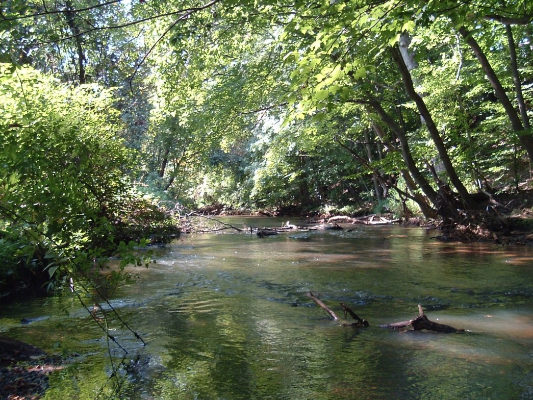
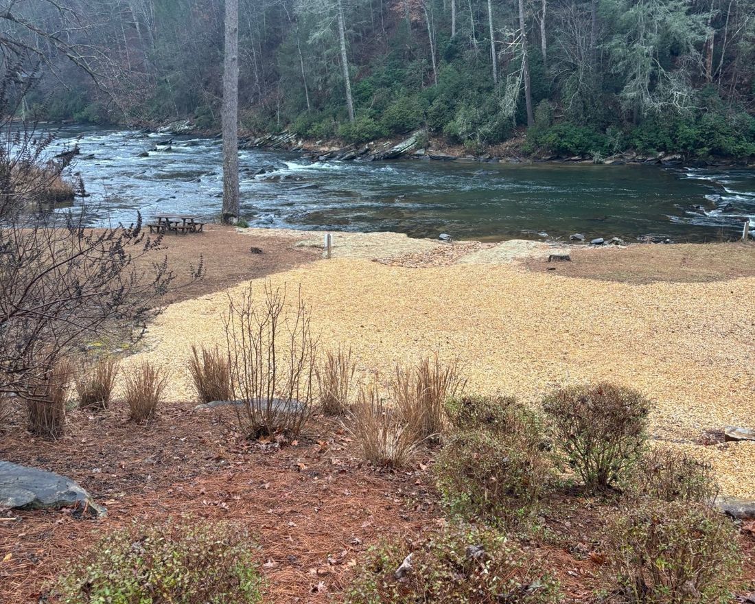
Photos: Georgia Soil & Water Conservation Commission, Level 1A certification training materials (header and left); owner documentation, Gilmer County (right).
The three buffer rules that apply here
Three overlapping rules — two state, one county — protect the waters that run through and past the resort. The foundation is the Georgia Erosion and Sedimentation Act of 1975 (GESA): these protections have been the law of Georgia for fifty years. A property owner, contractor, or association must comply with every rule that applies to a given stretch of water.
1. The 50-foot trout stream buffer — Mountaintown Creek and our creeks
Under GESA, O.C.G.A. § 12-7-6(b)(16), every state water designated as a trout stream carries a mandatory 50-foot undisturbed buffer. Under the state's trout-water designations, all streams in Gilmer County are designated trout streams — the sole exception is the Coosawattee River itself downstream from the Ga. Hwy. 5 bridge. Mountaintown Creek is a designated trout stream. The statute's command is unqualified: “No land-disturbing activities shall be conducted within a buffer and a buffer shall remain in its natural, undisturbed state of vegetation…” The State posts it on its own highway signs: “THERE IS A REQUIRED 50 FOOT UNDISTURBED BUFFER ALONG ANY STATE WATERS CLASSIFIED AS TROUT STREAMS.”
2. The 25-foot buffer — all other state waters
Streams that are not trout waters still carry a 25-foot undisturbed buffer under O.C.G.A. § 12-7-6(b)(15). “Land-disturbing activity” is defined broadly — clearing, dredging, grading, excavating, transporting, and filling of land (O.C.G.A. § 12-7-3(9)).
3. The 100-foot river corridor — the Coosawattee itself
The Coosawattee is a “protected river” under Georgia's River Corridor Protection criteria (DNR Rule 391-3-16-.04) because its flow exceeds 400 cubic feet per second. Gilmer County has adopted this into its own code: Chapter 86, Article II — Coosawattee River Corridor Protection. The state criteria require a 100-foot natural vegetative buffer on both sides of the river. Within the corridor, single-family homes are allowed only on tracts of two acres or more with one dwelling per tract; a septic tank is permitted but its drainfield is not.
What is — and isn't — allowed in a buffer
Not allowed without a variance: clearing, grading, excavating, filling, and construction of any kind — decks, patios, fire pits, retaining walls, walkways, structures. The prohibition is activity-based: it applies no matter who performs the work, who hired the contractor, or what the property is worth. And a permitting exemption (for “minor” activities under O.C.G.A. § 12-7-17(3), or for building a single-family home under § 12-7-17(4)) is an exemption from the permit process — the buffer prohibition still applies. Section 12-7-17(4) says so expressly: for primary trout waters, “the buffer zone shall be at least 50 horizontal feet, and no variance to a smaller buffer shall be granted.”
Allowed: once a construction site is fully stabilized, buffer vegetation may be thinned or trimmed — but only so long as “a protective vegetative cover remains to protect water quality and aquatic habitat and a natural canopy is left in sufficient quantity to keep shade on the stream bed” (O.C.G.A. § 12-7-6(b)(16)(A)). A homeowner who built the house for their own occupancy may thin or trim at any time, subject to the same vegetative-cover and canopy floor. Trimming is not clearing: if the stream loses its shade, the floor has been breached.
The one lawful path to disturb a buffer: a formal variance from Georgia EPD under Rule 391-3-7-.05. The variance process requires a detailed site plan, an erosion-control and re-vegetation plan, public notice with a 30-day comment period, and a demonstration that the activity will not harm water quality. If you are planning any work near a stream and think you need one, talk to EPD before the work begins.
The enforcement record: an unmitigated failure
Everything above is what the law says. Here is what the State's own records say about how it is enforced.
Read that first number again. These are not accusations — they are EPD's verified violations, in EPD's own database, obtainable by any citizen. In more than one case out of three, the agency's records show it did nothing at all. And when the agency does act, the tool of choice is the consent order: the violator pays a modest fine, plants some grass, and the deck or fire pit or retaining wall stays in the buffer forever. The statute calls for an undisturbed buffer and provides exactly one lawful path to disturb it — a public-notice variance. Records produced under the Open Records Act identify zero such variances for Mountaintown Creek across twenty years, a period in which structures appeared inside the buffer all the same. A prohibition that is never enforced is not a law. It is a suggestion.
How did “undisturbed” come to mean this? Follow the agency's own paper trail. In 2006, EPD's erosion-control procedures required two things when a buffer violation was confirmed: a penalty, and restoration — no discretion. In 2009, state guidance said flatly that the minor-activities exemption “does not provide an exemption from buffer requirements.” Then in 2017, a guidance memo appeared authorizing decks, patios, fire pits, and rip rap in the buffer if they stay under 100 square feet — a number that appears nowhere in any statute the General Assembly ever passed. EPD has confirmed in writing that the 2017 memo was never adopted through the Administrative Procedure Act, meaning it has no force of law. It is applied in the field anyway. And by 2024, an internal draft protocol — which EPD's own legal office concedes “has not been finalized” — quietly converted the mandatory duty to restore into a discretionary question: whether a “structural impact is allowed to remain.” Four documents, eighteen years, and a mandatory prohibition dissolved into a negotiation — without the legislature changing one word of O.C.G.A. § 12-7-6.
Meanwhile the State of Georgia still posts signs on its own highways: “THERE IS A REQUIRED 50 FOOT UNDISTURBED BUFFER ALONG ANY STATE WATERS CLASSIFIED AS TROUT STREAMS.” The sign is accurate. The enforcement is not. Our trout streams are protected by the strongest buffer language in the statute book and some of the weakest enforcement in it — and every owner on this river lives with the sediment, the warming water, and the failing banks that result. That is why the reporting steps below matter: the record only changes when owners put violations on it, in writing, with a complaint number attached.
How to report a buffer violation
Three levels of government share enforcement. Gilmer County Planning & Zoning is the certified Local Issuing Authority under GESA. Georgia EPD retains oversight and step-in authority under O.C.G.A. § 12-7-8. And the federal Clean Water Act sits above both: EPD administers the NPDES stormwater program under authority delegated by the U.S. EPA, and any work in the stream itself — fill, dams, bridges, channelization — requires a Section 404 permit from the U.S. Army Corps of Engineers plus a Section 401 water-quality certification from EPD (33 U.S.C. §§ 1341, 1344). If you see clearing, grading, excavation, or construction inside a stream or river buffer:
- Document it immediately. Photograph the disturbance and the stream, note the date, and identify the location (lot number, street, GPS if possible). Photos taken before a site is cleaned up or covered over are the evidence that matters most.
- Ask Gilmer County Planning & Zoning — (706) 635-3406, 1 Broad Street, Suite 002, Ellijay — whether a land disturbance permit or buffer variance exists for the property. You can request these records under the Georgia Open Records Act. (gilmercounty-ga.gov/planning-zoning)
- File with Georgia EPD — call the EPD Mountain District office in Cartersville at (770) 387-4900 (the district serving Gilmer County) or email AskEPD@dnr.ga.gov with your photos, the location, and the dates. Ask that a complaint number be assigned in EPD's Complaint Tracking System — that CTS number is your handle for tracking what happens with your report.
- Escalate federally when the water itself is disturbed. If fill, equipment, or structures are in the stream channel, that is federal Clean Water Act territory: report it to U.S. EPA (Report an Environmental Violation), which routes to EPA Region 4 in Atlanta, and ask whether a Section 404 permit and Section 401 certification exist for the work.
- Keep everything in writing. Complaint numbers, emails, and responses are all public records.
Sources
O.C.G.A. § 12-7-1 et seq. (Georgia Erosion & Sedimentation Act of 1975), including § 12-7-6(b)(15)–(16) (buffers), § 12-7-3(9) (definition of land-disturbing activity), § 12-7-17 (exemptions), § 12-7-8 (local issuing authorities and EPD oversight), §§ 12-7-12 through 12-7-15 (enforcement and penalties). Ga. Comp. R. & Regs. 391-3-7-.05 (buffer variance procedures); 391-3-16-.04 (river corridor protection criteria). Georgia EPD, Trout Stream Designations by County (Gilmer County). Gilmer County Code of Ordinances, Ch. 86, Art. II (Coosawattee River Corridor Protection). NPDES General Permit No. GAR100003, Part IV(iv). Federal Clean Water Act, 33 U.S.C. § 1344 (Section 404 dredge-and-fill permits, U.S. Army Corps of Engineers) and 33 U.S.C. § 1341 (Section 401 state water-quality certification). CRRA ARC Setback Requirements & Property Line Acknowledgment form (owner portal). Enforcement-record section: analysis of EPD’s public Complaint Tracking System database (99,128 complaints; 264,894 action records; 1998–2025; cts.gaepd.org); executed Erosion & Sedimentation Act consent orders and buffer-variance records produced by Georgia EPD under the Georgia Open Records Act, O.C.G.A. § 50-18-70 et seq.; EPD 2006 Erosion and Sedimentation Control Procedures; 2009 ESAC Minor Land-Disturbing Activity Guidelines memorandum; 2017 Minor Land-Disturbing Activities guidance; EPD written confirmations that the 2017 guidance was not adopted through APA rulemaking; EPD 2024 draft Complaint Protocol (produced Apr. 2026, unfinalized per EPD Legal Services).